Long Distance
Sunday September 17th
Canmore Nordic Centre
SCHEDULE
Info desk open: 8:30am
Start times: 10:00am - 11:00am. Go to start line when you are ready to start. Kids start no earlier than 10:20am
Max time allowed: 3 hours for point to point courses and 75 minutes for Score-O Sport Course
Course closes: 2:00pm
Awards: 1:30pm, approx
|
MAP INFO
Canmore Nordic Centre ISOM Scale: 1:15,000 / 1:10,000 / 1: 7,500
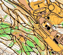
Updated: Remo Madella, 2015 Elevation: 1,400m (approx) Last major events: 2012 Barebones - click to see map & courses There has been some new trail building at the Nordic Centre which will not be reflected on the map - try not to be confused by new trails! |
TERRAIN DESCRIPTION
The Canmore Nordic Center is a world class nordic ski area located below Mount Rundle. There is a plethora of both contours and trails. There are several small creeks that drain the hillside, creating deep re-entrants.
Historically, Canmore grew as a mining town. There are features in the terrain that are a consequence of this. A large open meadow once active with coal mining now allows for fast running. There are also pits, cut lines, ruined foundations, and even spilled coal in some places.
The forest is categorized mostly as white or pale green. In recent years wind storms have caused blow down: both the wider and narrow vertical green lines are used to reflect this. Mountain bikers enjoy this terrain too. In addition to the wider ski trails there are many narrow winding bike trails. In fact there is very active work in building more small mountain bike trails and and in June alone we have added six more to the map. Almost certainly there will be new sections of trails built between the final map updates and race day. Picnic benches and garbage bins are not marked but larger ski shelters are. There are a number of boulders. Small game trails and old bike paths which have been reclaimed are generally not marked.
The trail network is very dense and it can be very challenging to interpret which trail is which.
|
OFFICIALS
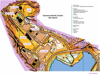
Course planner: Jane Rowlands, FWOC Assistant: Kitty Jones, FWOC Controller: John Rance, GVOC 2016 COC officials: Controller: Alan Vyse, Sage IOF Event Advisor: John Rance, GVOC ARENA INFORMATION Food: bring your own. There is a small cafe in the day lodge. Water: bring your own. There are water fountains in the day lodge. Toilets & showers: toilets with running water are available in the wax building and the team building. The bathrooms in the Wax Building have a coin-operated shower. Distance from Parking to Arena: max 500m easy. Distance from Arena to Start 1: 1km, 80m climb along good trails Distance from Arena to Start 2: 450m, 10m climb along good trails |
site map
|
STARTS
There are two start locations, a higher start (Start 1) for most classes and a lower start (Start 2) for older age groups.
Start 1
Follow the marked route through the warm-up map. Allow plenty of time for the big climb, and think how wonderful it is to do the climb before starting the race!
Start 2 - M75, M80, M85+, W75, W80, W85+
Meet at the Registration Desk at the "Wax Building" at 10:15. Everyone will be escorted together to the Start 2 location. Think how wonderful it is to not have to do the climb at all!
WARM-UP MAP
There will be a small warm-up map available covering the area close to Start 1. This will give you a chance to experience the mapping style, terrain, and vegetation. Pick up a copy at the Information desk.
RACE NOTES
We share CNC with other outdoor enthusiasts. There will be mountain bikers using the trails. Be alert and respect them, and realize that they may not be able to stop as fast as you can. The paved trails have been closed for roller skiing during our event and so there should not be any roller skiers, but if there are remember these folks do not have brakes. On the more advanced courses please take care around the cliffs.
There are three out of bounds areas: the biathlon range; the bike park which is under construction; and Frozen Thunder snow storage – you must not cross this mound of sawdust-covered snow even where there is no fence. We also share the terrain with wildlife, stay alert at all times.
OTHER NOTES
Carrying bear spray is mandatory in this event for all adults (18 and over). Please see the Bear Spray page for more information.
DIRECTIONS
The Canmore Nordic Centre is a short (5 minute) drive from downtown Canmore. Jump to the Locations page for a map.
Note: There is often photo radar on the bridge over the Bow River where the speed limit is 30km/hr. Take this speed zone very seriously to avoid a ticket!


